Do you know the size and location of India on the map of the world? If not, through this post, “India Size and Location Class 9 notes” you will learn about India’s extent and standard meridian, India’s contact with the world through the International Highway of Trade and Commerce, and India’s neighbouring countries. So, go through this post and learn the Size and Location of India as an easy concept.
India Size and Location Class 9 Notes Summary
Location:
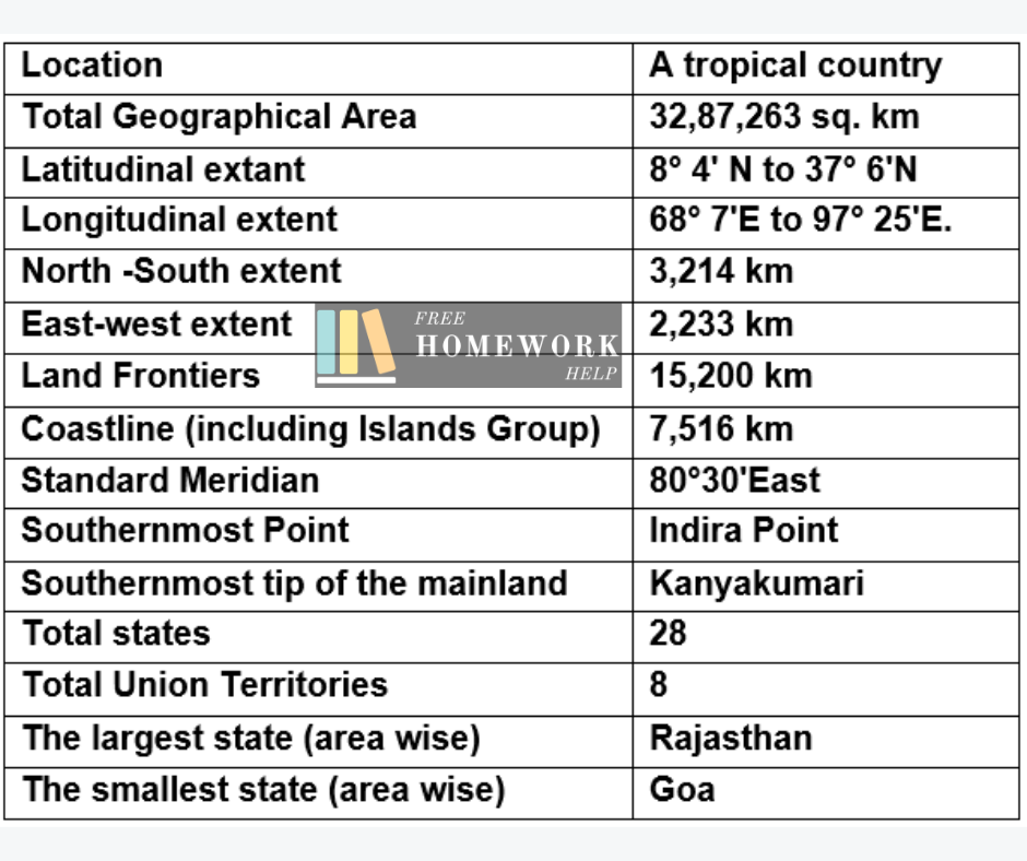
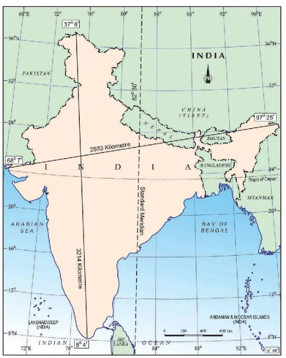
India is situated in the Northern Hemisphere. Its latitudinal extent is between 8° 4′ N to 37° 6’N and its longitudinal extent is between 68° 7’E to 97° 25’E. It is surrounded by water on three sides – the Bay of Bengal in the southeast, the Arabian Sea in the southwest, and the Indian Ocean in the South. India is located at the head of the Indian Ocean.
Size:
- The geographical area of India is 32.8 lakh sq. km. It measures about 3,214 km. from north to south and 2,933 km from east to west.
- The total length of the land border from northwest to northeast is about 15,200 km. The length of the coastline is 7,516.6km including the Lakshadweep and the Andaman & Nicobar Islands.
- The Tropic of Cancer divides India into two equal halves which pass through 23° 30’N latitudes. The southern half lies in the tropical zone & and is known as Peninsular India and the northern half lies in the subtropical zone.
- The young fold mountains in the north, northwest, and northeast surround India.
- In size, India accounts for 2.4% of the total geographical area of the world.
- India ranks seventh in the world followed by Russia, Canada, the USA, China, Brazil, and Australia.
- In respect of population, India occupies the second position after China.
Standard time:
- There is a time lag of two hours from Gujarat to Arunachal Pradesh.
- The standard time of India has been taken from the Standard Meridian of India (80°30’E) passing through Mirzapur in Uttar Pradesh.
- The standard time in India is 5 hours 30 minutes ahead of Greenwich Mean Time. It is known as Indian Standard Time.
India and The World:
- The landmass of India has a central location between East and West Asia. it lies at the southward extension of the Asian Continent. it connects the Western European countries and the East ns Indian Ocean routesAsian countries by the trans-Indian Ocean routes.
- India has the longest coastline and the most prominent position on the Indian Ocean, which truly justifies the ocean’s name after it.
- India’s contact with the world has continued throughout the ages.
- The spices, muslin, and other merchandise were taken from India to different countries of the world.
India’s Neighbours:
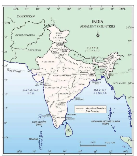
- India is a vast country having 28 states and 8 union territories.
- India shares its international boundaries with-
- Pakistan in the West
- Afghanistan in the northwest
- China, Nepal & Bhutan in the North
- Myanmar and Bangladesh in the East
- Sri Lanka & Maldives, are the two islands in the South.
- There is a narrow channel between India and Sri Lanka which the Palk Strait forms.
Extra Info: India size and location class 9 Notes
- India’s distance from Europe has been reduced by 7000 km due to the opening of the Suez Canal in 1869.
- Before independence, India had two types of states Provinces which were ruled by British officials, and Princely states which were ruled by local, hereditary rulers.
- The Southernmost point of India ‘Indira Point’ was submerged under seawater in 2004 during the Tsunami.
- The northernmost point of India is the Siachen Glacier.
India size and location class 9 extra questions
1. In which hemisphere is India located?
Answer: Northern & Eastern Hemisphere.
2. What is the latitudinal extent of India?
Answer: 8° 4′ N to 37° 6’N
3. What is the longitudinal extent of India?
Answer: 68° 7’E to 97° 25’E
4. Which water body is located in the southeast of India?
Answer: Bay of Bengal
5. Which water body is located in the southwest of India?
Answer: Arabian sea
6. Which water body is located in the south of India?
Answer: Indian Ocean
7. Which ocean is named after the name of a country?
Answer: Indian Ocean
8. What is the geographical area of India?
Answer:32.8 lakh sq. km.
9. What is The total length of the land border of India?
Answer: About 15,200 km.
10. What is the length of the coastline of India including the Lakshadweep and the Andaman & Nicobar Islands?
Answer:7,516.6km.
11. Which latitude divides India into two halves?
Answer: Tropic of Cancer
12. Name the states from which the Tropic of Cancer passes.
Answer: Gujarat
Rajasthan
Madhya Pradesh
Chhattisgarh
Jharkhand
West Bengal
Tripura
Mizoram
13. Why is India called a peninsular?
Answer: India is called a peninsular because it is surrounded by water on three sides.
14. What is its rank of India in the world (area)
Answer: Seventh
15. Which meridian is the standard meridian of India?
Answer: 80°30’E which passes through Mirzapur near Allahabad in Uttar Pradesh.
16. which state of India has the longest coastline?
Answer: Gujarat
17. Which is the largest state(area) of India?
Answer: Rajasthan
18. Which is the smallest state (area) of India?
Answer: Goa
19. How many states are there in India?
Answer: 28 state
20. How many union Territories are there in India?
Answer: 8 unions Territories
21. Which union territory is found on both the Eastern Coast and Western Coast?
Answer: Puducherry
22. Which channel separates India from Sri Lanka?
Answer: Palk Strait
23. Which Indian state is known as ‘The Land of Dawn’?
Answer: Arunachal Pradesh
24. With which countries India shares its land boundaries?
Answer: Pakistan & Afghanistan (North-west)
China, Tibet, Nepal & Bhutan (North)
Myanmar & Bangladesh (East)
25. Which states do not have an international border on the coast?
Answer: Madhya Pradesh, Chhattisgarh, Jharkhand, Telangana & Haryana.
26. When did the Suez Canal open?
Answer: The Suez Canal was opened in 1869.
27. Which island is an active volcano formed in Andaman Nicobar Island?
Answer: Barren Island near Nicobar Island.
28. Which group of islands was submerged under the sea during the Tsunami of 2004?
Answer: Indira Point in Andaman and Nicobar Island.
29. Which is the most populous country in the world?
Answer: China
30. Which is the second most populous country in the world?
Answer: India
Also Read: India Size and Location Class 9 Geography Chapter 1 Solution
FAQ of India Size and Location Class 9 Notes
What is the size and location of 9th-class India?
India is a country located in South Asia. It is the seventh-largest country in the world by land area, covering approximately 3.29 million square kilometres.
What is India and its geographical location Class 9?
India is covered by the Himalayan Mountains in the north, the Indian Ocean in the south, the Arabian Sea in the west, and the Bay of Bengal in the east. It is located in the northern hemisphere and in the eastern hemisphere.
What is the importance of the geographic location of India Class 9?
India’s location provides strategic advantages, such as being situated in the Indian Ocean region, allowing for easy access to important trade routes and facilitating trade and maritime activities with other countries.
Conclusion of India Size and Location Class 9 Notes
I hope the information given above regarding Class 9 Geography Chapter 1 notes has been helpful to an extent. If you have any other queries about NCERT India size and location class 9 notes feel free to reach us so that we can get back to you at the earliest possible.